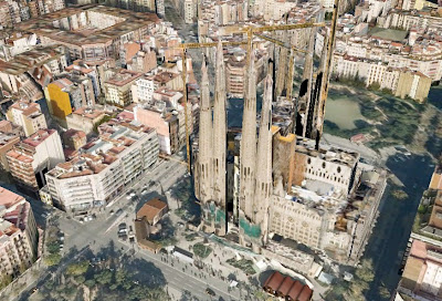
Next the Google guys teamed up with UNESCO to give even more detail on the city and its sights. Barcelona council got on the scene with their virtual flight over Barcelona and there's already an amazing project underway at Barcelona 3D. Not being one to feel left out, Google announced last week that Barcelona can also be viewed in 3D on Google Earth (requires installation).

Consider the above image, which I have stripped of all the usual ads and other people's photographs. It may take you a couple of seconds, but that is indeed how Sagrada Familia looks on a standard Google Earth (which is a bit like Google Maps, too). The shadow probably gives it away more than anything else. Well, with the simple click of your mouse, you can inflate the buildings presented in front of you into a 3D version - literally before your eyes. It's quite funny the first time, hence the silly title for the post.

Now before you all go accusing me of being a geek, I do realise that the 3D version of the picture is also still a bit pants, but it's still a pretty cool tool to move around and have a look at the city from another angle (and is much better than the council flight simulator - sorry council!). What would be really cool is if street view could somehow be integrated into this system as well, and you could literally plan your itenerary and see where you're going to go before you even got there!!!???
 Expanding - or "blowing up" - the view of the buildings couldn't be easier. To the left hand column of menu bars, you have a section called "Layers" and within layers, you just need to mark the box "3D Buildings", and then you can see them all. Good, eh? What do you think about the 3D thing? An improvement to Google Earth, or something people are likely not to use? I'd be happy to hear your comments, so feel free to leave one below.
 And if you're coming to the city some time soon, check out these Barcelona Apartments, instead of staying in a hotel.


0 comments:
Post a Comment